Showing posts with label segregated. Show all posts

Sunday, 12 November 2017

Manchester's Flagship Cycleway?

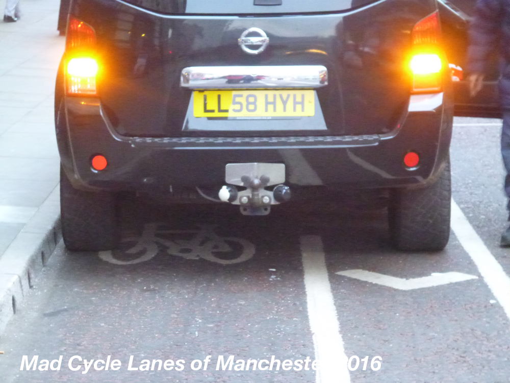
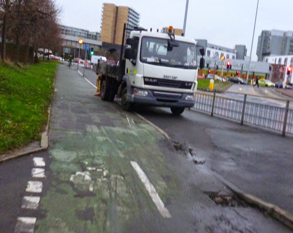
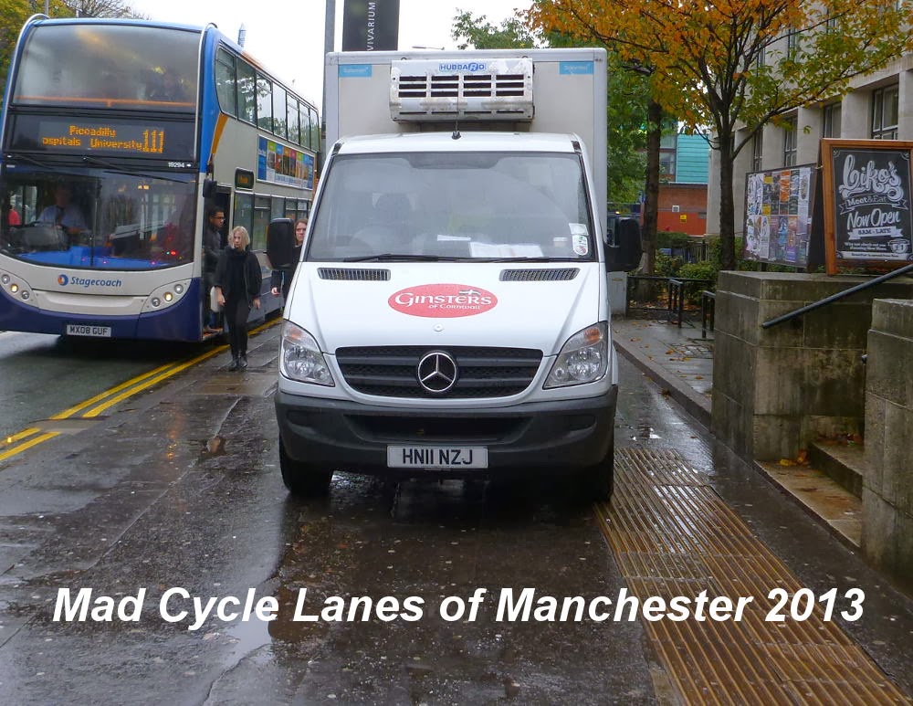
I don't think I've ever been along Oxford Road on a bike without having to swerve into the road to avoid taxis, roadworks or other obstructions.


The taxi drivers block it all the time.


This is also a common occurrence.


The roadworks never seem to stop.


When combined with taxis it makes the cycle way almost pointless.


Sunday, 4 December 2016

Oxford Street Southbound - Useless!

I am beginning to think we should call this sort of thing "flagshit infrastructure"

Why on earth is there no kerb separating the cycle track from the parking spaces?

This idiot had no idea what he was doing and didn't care...


Yes this is a cycle track...


Further south it becomes a slalom - this is just dreadful.


Somehow I wish the traffic engineers had thought cyclist!


Useless!

Saturday, 10 January 2015

Keep on Complaining

My cycle route to work has been screwed up for the past year with all sorts of closures and other crap, but last week I saw something that just looked like the local council sticking two fingers up to those of us who cycle. Last Wednesday, on the one short section of segregated cycle track on my route a set of council workmen had ignored the access road to the right of the track and driven their vehicles along the cycle track.


So later that morning I posted the following on twitter


and followed up in the evening with a second message that also went to the senior Councillor responsible for highways.


As you can imagine, on Thursday morning the vehicles were still there, this time two lorries on the cycle track and pavement just further along.

So I posted two new photos on twitter


This time, I got a response..
So I replied with the location and an extra picture and got an acknowledgement.


Well, by Friday morning the council workman had moved along the cycle track, and were now obstructing the cycle lane beyond.

So another day another tweet...


By the afternoon the city council had take some sort of action, and a number of people along the way had seen that driving council vehicles illegally on cycle tracks was a PR problem.
This sort of thing doesn't change the world overnight, but keeping up the pressure on our local authorities will get through in the end. After all that is what the petrolheads do all the time...

So keep on complaining!

Sunday, 19 January 2014

Design Options for Oxford Road 2

The Oxford Road Flashmob took place nearly nine months ago, a short demonstration of over 100 people with pedal cycles showing just how much we cared about the future plans for cycling in Oxford Road and the wider Manchester area.


So how are the plans progressing?

At last Tuesday's meeting at Oxford road TfGM asked the attendees to rate various options for the Oxford Road cycling infrastructure.

It soon became clear that they had only come up with a narrow range of options, many of which were completely unsuitable.

All the way through their options referred to "cycle lanes" not cycle tracks etc, implying on-carriageway provision. For simplicity I will stick to the same terminology in this post...

Cycle Lane Widths

We were only offered two options, 1.5 metre or 2 metre wide both of which seem too narrow, so I checked my copy of "Cycle-friendly Infrastructure" (1996) which I had taken along for reference.

Now this specifies lane widths as a minimum of 1.5m and 2m wide wherever possible and says that if cycle flows are heavy (above 150 cyclists in the peak hour) 2.5m may be necessary. (11.3.2 pg46)

So I asked what the projected traffic flows are for Oxford Road. The reply was that they were already around 200 in the peak and were projected to rise to around 600. So it is clear that if these were just cycle lanes then they would be too narrow at 2m. However, we are aiming for segregated cycle tracks along Oxford Road, quite separate from the road.

I have now found the section in Cycle-friendly Infrastructure that refers to "Off-carriageway but within the highway"

This states that cycle tracks should be a minimum of 2m wide, so the option of 1.5m is totally unacceptable for the Oxford Road designs.

Unfortunately Cycle-friendly Infrastructure (1996) is not available on line and Local Transport Note 2/08 October 2008 Cycle Infrastructure Design which is on line does not contain advice about cycle flows.

My conclusion is that the segregated cycle lanes on both sides of Oxford Road need to be at least 2.5m wide to cope with the cycle flows at peak time and preferably 3m where possible.

The TfGM officers did accept that it may be possible to find space for 2.5m wide lanes in some parts of Oxford Road...

Cycle Lane Carriageway Segregation

We were shown 8 options for the lane/track design, sadly none of them are totally acceptable...
The first issue I raised was the question of maintenance. This was acknowledged as a problem. If the measures were made from breakable materials then there would have to be ongoing replacement. The 8 options were:-

1 - White line hatch segregation

This is just a cycle lane with 0.7m of hatching between it and the bus lane. It offers no segregation from buses and taxis. Taxi drivers are very likely to drive into the cycle lane to collect and drop off passengers. This option is simply not what was offered in the consultation and is totally unacceptable.


Cycle Superhighway 2 - photo from London Cycling Campaign

2 - White line hatch/Flexible bollards segregation

These plastic bollards are a great way to quickly and cheaply convert an entire traffic lane into a cycle route. They have been used in parts of the USA to relocate road space to cycling. However, they are easily broken by motor vehicles, as they rapidly discovered on the NW Lovejoy Ramp in Portland.


"Soft-hit" bollards in San Francisco. Photo: Steven Vance

There is also the problem that they are very ugly. If these were installed on Oxford road en-mass it would not be long before there was a campaign to get rid of them, and we would be pushed back into unsegregated cycle lanes.

3 - White line hatch/Armadillo segregation

The armadillos are a new product from Spain that has not been in use for long so there is little evidence of their impact.


Photo from manufacturer's web site.

They are low plastic humps which would not prevent a bus or taxi entering the cycle lane and will provide very little feeling of separation for those on bikes. It is made from recycled plastic which means they are likely to be damaged and degrade over time.

They are also pretty ugly and easily removed.

Many of us at the meeting think that they may also be unsafe, particularly when placed at an angle to the cycle lane. Some free samples have been sent over which are going to be tested in Salford along Liverpool Street/Middlewood Street, so we will get a chance to see them.

4 - White line hatch / Armadillo / Planter segregation

This is the approach taken by Camden in Royal College Street.


Photo by The Alternative Department for Transport

It is a real dog's breakfast, whilst the planters may provide the feeling of separation they are a real safety hazard and maintenance problem. The planters are big solid objects with sharp edges which will do serious damage to anyone on a bike who runs into them. As for maintenance, is anyone going to look after the plants and remove all the rubbish that gets thrown in? Very unlikely.

5 - Combination segregation

This is just a combination of option 2 and option 4 with the combined problems of both. Just dreadful.

6 - Island segregation with gateways

This is a UK-style segregated cycle track, as you can already find along Hulme Hall Lane & Alan Turing Way in Manchester.


The big problems with this design is the height of the curbs on the sides of the cycle track make the rider feel hemmed in and reduce the useful width of the track. You wouldn't want to catch a pedal on those full-height curbs.

Also, even a full height curb wouldn't prevent a determined driver from getting onto the cycle track, but it is at least clear from the design that this is a separated part of the highway.


Cycle Superhighway 2 - photo from London Cycling Campaign

7 - Island segregation with gateways, combined with bollards

This combines the above with the plastic bollards. It helps reduce encroachment from drivers, but would look pretty ugly.

8 - Segregation by elevation

This is the most visually attractive option, and the only true, "Dutch Style" option on offer.


Photo from London Cycling Campaign

However, in the context of a main road like Oxford Road this is not the approach you see in the Netherlands, because it can easily be invaded by motor vehicles, and would be extensively used by taxis to drop off and pick up passengers.


Old Shoreham Road cycle track,
photo from As Easy As Riding A Bike.

How it should be done...

Raised cycle track with curb separation

One Dutch approach in this sort of context is to put a raised curb between the cycle track and the road.


Photo from As Easy As Riding A Bike.

This has the advantage of the raised curb in increasing segregation and meaning that the cycle track itself has only shallow, sloped curbs, making the full width of the track usable for cycles and reducing the feeling of enclosure.

This was the approach that I suggested durring the meeting and TfGM and MCC officers were receptive to the idea.

Raised cycle track separated by street furniture

This is how it should really be done.

The most common approach to busy wide main roads and cycle tracks in Amsterdam is to place the street furniture (trees, lamp posts road signs etc) between the cycle track and the road.


Photos from Sustainable Transportation in the Netherlands

This provides a complete separation between the motor traffic and pedestrians and bikes. This approach also creates a calmer streetscape for people and the separation is enforced bt street furniture which would otherwise clutter up the pavement.

I am sure that this approach would create a far more attractive and safer environment on Oxford Road than any of the options currently on offer.

This image of Vassar Street - Cambridge MA shows a cycle scheme in the USA which uses the same approach in a context that looks similar to Oxford Road.

Image taken from "Cycle Tracks: Concept and Design Practices"

I hope we can persuade TfGM, Manchester City Council, Corridor Manchester, the Universities and some cycle campaigners that this approach is the best solution for Oxford Road.


Tuesday, 5 November 2013

Oxford Road - Pavement Driving

It is depressing to walk along Oxford Road sometimes. There are plans for Dutch style cycle routes along the road, but what hope is there when road traffic law is not enforced?


The pavement along Oxford Road is regularly used as a car park by lazy delivery drivers who seem to get away with driving on the pavement.


I fear that when we do get the segregated cycle lanes they will simply become car parks for lazy drivers and drop off areas for taxis.


As was illustrated by this sight further along the road....

Sunday, 16 June 2013

Oxford Road Consultation - Respond Now!

This is the most important consultation for cycling in many years in Manchester. This consultation is for the bus priority package along Oxford Road, but it is also the busiest cycle route in Manchester so if TfGM get this route right it sets the standard for the rest of the city.


The closing date is Friday 5 July 2013.

The current plan is to remove all lorries, vans, private cars, motorbikes and private hire vehicles from the section covering the university and hospital and impose a 20mph speed limit. As a result there will be many motoring groups, shop owners and others lobbying against this scheme.

Cycling could lose out if we don't all respond to support the main principles of the scheme. However the details of the cycle route are not all as good as they should be, so we need to respond to agree with the removal of the traffic and the principle of protecting people cycling from the buses and then press for a much higher quality of cycle route design than is currently proposed.

Here is a video showing how this kind of cycle route is designed in the Netherlands with continuous cycle tracks that give priority across junctions and pass round the back of bus stops without conflict.


---------------------

How to Respond.

Take a look at this video to see what is proposed, and notice how the cycle tracks could be improved.


If you need more information you can download the leaflet but it doesn't show the same cycle track details.

Then compose your response in a text editor of some sort because there isn't space in the web form to see everything you have written.

Write as little or as much as you feel appropriate, but please remember to:-

1) Support the removal of the traffic from this route.

2) Support the 20mph speed limit.

3) Support the idea of a high quality cycle route, protected from the bus traffic.

4) Call for the cycle route design to be improved - if necessary by employing experienced engineers from the Netherlands to finalise the design.

5) And if you regularly cycle along Oxford Road then include this information in your response and write about your current experience and how you want it to improve.

Once you have written your response, then visit the online form, fill in your name, full address, postcode and email address. It is important that our responses are seen to come from individuals who live in the area.

Then copy and paste your text into the box marked "Your views*", scroll through to check it's all there and hit the submit button.

Then tell every cyclist you know to do the same...

----------------------
You can also send your response by email to buspriority@tfgm.com or post it to

Transport for Greater Manchester bus priority,
FREEPOST RRHE-RKUU-KSJY,
Manchester,
M1 3BG

----------------------

Update:

I've now sent my response in.

I've also called for the cycle tracks to be suitable for all types of cycles including hand-cycles, rickshaws and cargo cycles.

I've also called for physical barriers between the cycle track and the Bus/Taxi lane to stop taxi drivers pulling off onto the cycle track to drop off passengers.

-------------------------

Further update

I have just received an email admitting that the cycle tracks along Oxford Road will be inconvenient for many cyclists and the writer will be using the road.

We must call for high quality Dutch provision. In the Netherlands you do not see lots of people refusing to use the cycle tracks because they are crap!

Sunday, 24 March 2013

When Cycle Tracks End...

The A56 Chester Road/Bridgewater Viaduct heading north east towards Deansgate has a two way cycle track on the right hand side. for people cycling south east it is ok, just so long as you watch out for traffic at the junctions.

However, if you are using it to cycle north west you are in for a nasty shock...

It is tricky to cross junctions on the wrong side of the road, and here at the junction with Great Jackson Street the road eats into your space making curved give way lines.


Carrying on it doesn't seem too bad,


but if you are aiming to go north up towards Deansgate then the most obvious thing to do is take this left turn.


However, as these two lads find, you are simply dumped into the path of oncoming traffic.


The large raised traffic island then gets in your way, making things even more dangerous.


From here on it is anyone's guess, one of them goes straight on to the pavement whilst the other dives left across the road.


He did make it across safely, leaving his mate going up the pavement on the other side of the road.


This is one of the worst examples of dangerous cycling half-measures in Manchester, that I have found. I know of one person who was hit by a car here 10 years ago, and I am sure there have been more. I think this was a facility that was unfinished, rather than designed to be this dangerous, but either way round it should never have been left like this.

I find it far safer to stick to the road going north east on Chester Road, and avoid this track altogether.


View Larger Map

Sunday, 23 September 2012

The Trans Pennine Trail - Part 1, Heatley to Dairyhouse Lane

This is a three and a quarter mile section of former railway from the edge of Rushgreen just over the border in Cheshire to the edge of Broadheath in Trafford where the railway trackbed is obliterated by the construction of George Richards Way.

This section starts opposite the Co-op supermarket with a relatively wide A frame barrier.


The path is quite narrow here with low overhanging trees. The path has a reasonable grit surface, but with a number of puddles.


The route emerges from the trees a short way later, at the site of the old Heatley and Warburton Station and level crossing.


After crossing Mill Lane there is another A frame and a horse step, with the sign showing that this section is also open to horses.


After a short paved section the path soon degrades to a grit surface with muddy puddles under some of the trees.


The path soon opens out and crosses the River Bollin and into Trafford.


Before narrowing somewhat.


For a while the trackbed rises high enough to see over the Cheshire landscape,


but the hedges are quite high in places.


This bridge takes you under Dunham Road.


A little further along is Station Road, the site of Dunham Massey Station and level crossing.

Here you hit the first of a set of dreadfully over-the-top cycle barriers which mean that everyone using the trail, except horse riders, has to dismount. for a disabled rider on a handcycle or trike these barriers prevent them from using the route. Manc Bike Mummy has written an extensive post about these barriers though I don't think her proposed solution is viable, far better to remove the horse steps.


At this point I saw a number of people who couldn't get their bikes through the kissing gate and resorted to lifting bicycles through the muddy horse step.

The Trans Pennine Trail web site documents many of the barriers and their problems, the attitude of the local authorities who build them and the way in which they prevent people with mobility problems using the trail.


Further along the path passes Heatley Farm,


before going under School Lane.


On the far side of the bridge the path opens up with fleeting views of the adjacent farmland before diving into this atmospheric tunnel through the trees.


However, you soon come across the extensive car park at Seamon's Road,


and the final set of over-engineered barriers at Dairyhouse Lane.


Link to Seventh Series OS map of the route when the railway was still in place.


The next part of The Trans Pennine Trail - Part 2, Dairyhouse Lane to Woodcote Road is on road.


View Trans Pennine Trail in a larger map