Not sure this needs any words... it's just unbelievable.
Watch out for the way that motor cycles have been parked on the cycle track...
Once Oxford Road has been sorted I suspect this will be chaos.
Showing posts with label Velocity 2025. Show all posts
Showing posts with label Velocity 2025. Show all posts
Sunday, 8 May 2016

Saturday, 7 May 2016
Wilmslow Road Southbound - 2 Videos
A view from the handlebars - the Curry Mile cycle slalom and beyond - watch out for the point where I get cut up by a bus driver...
Looks like it still hasn't been finished yet!
Going further South - more problems with bus drivers.
Thrown together from bits & pieces.
Did you spot the advance cycle green lights? Blink and you miss them - tokenism at its worst.
Looks like it still hasn't been finished yet!
Going further South - more problems with bus drivers.
Thrown together from bits & pieces.
Did you spot the advance cycle green lights? Blink and you miss them - tokenism at its worst.
Sunday, 24 January 2016
Curry Mile Cycle Tracks - early preview
I haven't been down Wilmslow Road for a few months, so I wasn't aware of the level of progress that is being made on the Curry Mile. The plans for this route were a real mixed bag. It was good that the council were aiming for proper cycle tracks, but the design completely failed to address the issue of safety at junctions.
The section southbound from Rusholme Place is sort of open, so here's a quick preview of what it looks like so far...
The first thing you notice is the way the cycle track abruptly moves from the cycle lane across the junction, left to go behind the parking spaces.

The second problem is the attitude of the contractors who see no problem with dumping traffic signs in the cycle track, on the wrong side of the parked cars where no diver can see them.

At the junction with Banff Road you clearly see a problem with the way the kerbing is cut back to allow vehicles to swing round the corner into the path of cyclists. I suspect this will be a significant problem along much of this route. Drivers are invited into the junction by its shape rather than feeling that they are intruding, as would be the case if they were presented with a raised kerb to cross.

Past Banff Road you can see how somebody has responded positively to our concerns about people parking on the cycle track by putting in this continual row of half-height bollards (sadly only plastic). The nice thing is that they add a feeling of continuity and they help visually distinguish the cycle track from the pavement.

However, some of the larger gaps in the kerbing will provide the opportunity for drivers to get onto the cycle track and pavement. Stand by for lots of photos of taxis, vans & cars blocking places like this.
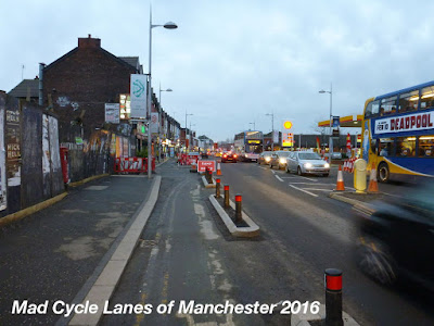
Further along there is another sudden lurch to the left and a narrowing of the track.

The track is already attracting people to cycle along it, and I saw very few people walking along it.

At the junction with Great Western Street the pavement has been sacrificed to allow two lanes of traffic at the junction and this phone box allows clear comparison with the original pavement, as well as causing another nasty kink in the cycle track. The cycle track is also very narrow in places, which makes me wonder how trikes will manage along here...

...particularly Errand Trike.

At the junction itself they have yet to sort out the traffic light too.

In general, the design has sacrificed pavement width to provide space for additional traffic lanes and unnecessary car parking.

At the junction with Dagenham Road there is another nasty kink in the track

followed by an unprotected junction and another nasty kink back to the left afterwards.

The open section of track currently ends at Denson Street. Here you can see another potential problem with the design. The drains are all in the cycle track, so it is, for the most part lower than the rest of the road surface. This means it is likely to end up blighted by puddles and the surface will degrade quickly in the winter.

Here there is another unprotected junction. You currently have to get out onto the road and compete with the buses for space.

However, it may not be long till the next section is open. Here there are also full height bollards designating the edge of the pavement, not quite sure why.

All in all, the route looks like it will be a big improvement over the useless cycle lanes which slalomed round the bus stops, and left you fighting with buses cars and taxis for space. The main safety problem along here was caused by the bus stops and parking movements.
However, the poor design of the junctions poses a safety issue, and many are likely to come a cropper with the sudden changes in direction. I expect this route will see an increase in the level of cycling, but little change in the number of incidents. Time will tell.
Ultimately, there may be an even bigger danger resulting from this scheme. Bus drivers seem to be getting more aggressive towards people cycling along Wilmslow Road. Some now seem to think that anyone not in a cycle track is fair game, and I was cut up by a bus near Platt Fields Park and then shouted at for not using the tiny section of cycle track at that point. I suspect we may see much more of this kind of behavior in the near future as there is a history of similar behavior in Manchester.

The section southbound from Rusholme Place is sort of open, so here's a quick preview of what it looks like so far...
The first thing you notice is the way the cycle track abruptly moves from the cycle lane across the junction, left to go behind the parking spaces.

The second problem is the attitude of the contractors who see no problem with dumping traffic signs in the cycle track, on the wrong side of the parked cars where no diver can see them.

At the junction with Banff Road you clearly see a problem with the way the kerbing is cut back to allow vehicles to swing round the corner into the path of cyclists. I suspect this will be a significant problem along much of this route. Drivers are invited into the junction by its shape rather than feeling that they are intruding, as would be the case if they were presented with a raised kerb to cross.

Past Banff Road you can see how somebody has responded positively to our concerns about people parking on the cycle track by putting in this continual row of half-height bollards (sadly only plastic). The nice thing is that they add a feeling of continuity and they help visually distinguish the cycle track from the pavement.

However, some of the larger gaps in the kerbing will provide the opportunity for drivers to get onto the cycle track and pavement. Stand by for lots of photos of taxis, vans & cars blocking places like this.

Further along there is another sudden lurch to the left and a narrowing of the track.

The track is already attracting people to cycle along it, and I saw very few people walking along it.
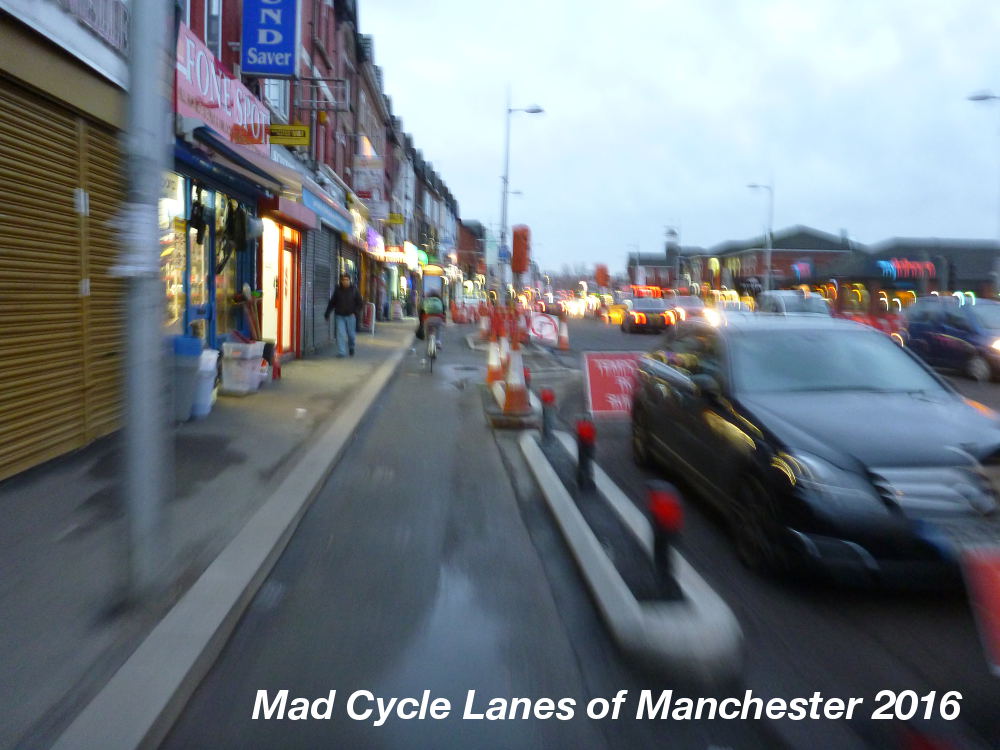
At the junction with Great Western Street the pavement has been sacrificed to allow two lanes of traffic at the junction and this phone box allows clear comparison with the original pavement, as well as causing another nasty kink in the cycle track. The cycle track is also very narrow in places, which makes me wonder how trikes will manage along here...

...particularly Errand Trike.
At the junction itself they have yet to sort out the traffic light too.

In general, the design has sacrificed pavement width to provide space for additional traffic lanes and unnecessary car parking.

At the junction with Dagenham Road there is another nasty kink in the track
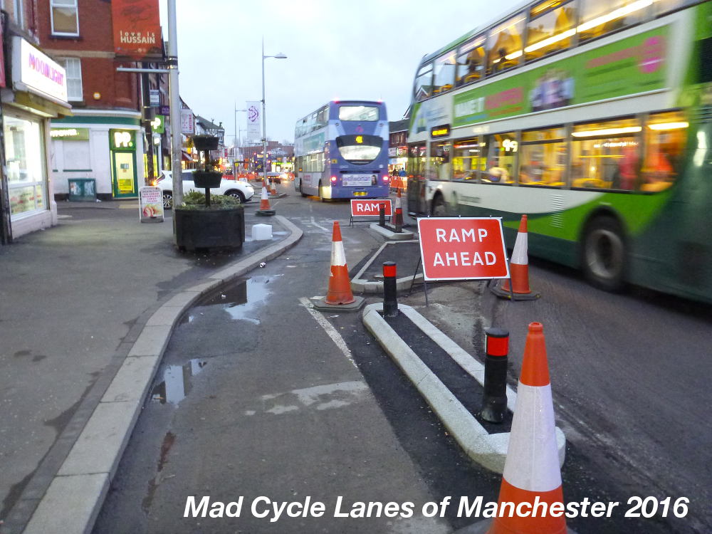
followed by an unprotected junction and another nasty kink back to the left afterwards.

The open section of track currently ends at Denson Street. Here you can see another potential problem with the design. The drains are all in the cycle track, so it is, for the most part lower than the rest of the road surface. This means it is likely to end up blighted by puddles and the surface will degrade quickly in the winter.

Here there is another unprotected junction. You currently have to get out onto the road and compete with the buses for space.

However, it may not be long till the next section is open. Here there are also full height bollards designating the edge of the pavement, not quite sure why.

All in all, the route looks like it will be a big improvement over the useless cycle lanes which slalomed round the bus stops, and left you fighting with buses cars and taxis for space. The main safety problem along here was caused by the bus stops and parking movements.
However, the poor design of the junctions poses a safety issue, and many are likely to come a cropper with the sudden changes in direction. I expect this route will see an increase in the level of cycling, but little change in the number of incidents. Time will tell.
Ultimately, there may be an even bigger danger resulting from this scheme. Bus drivers seem to be getting more aggressive towards people cycling along Wilmslow Road. Some now seem to think that anyone not in a cycle track is fair game, and I was cut up by a bus near Platt Fields Park and then shouted at for not using the tiny section of cycle track at that point. I suspect we may see much more of this kind of behavior in the near future as there is a history of similar behavior in Manchester.

Sunday, 5 July 2015
Bridgewater Way 1 - Deansgate to Throstle Nest Bridge - not fit for purpose
This is the first in a series of posts revisiting the newly resurfaced Bridgewater Way. This first one was prompted by Manchester City Council's consultation which refers to this section of canal towpath when in the works here have more or less finished. This is in itself a repeat of a previous consultation by MCC for the same junction over a year ago.

Taking the position of the sculpture Life Cycle by George Wyllie as the start of this route you turn down the quiet part of Deansgate.

Now you have to look very carefully to your right to see the path under the block of flats. One of these parking spaces is planned to be removed to enable access.

From here is the end of the Manchester City Council section and the beginning of the path on Peel Holdings land. There has been some work on this section with textured pavement, though there is no benefit for cycles.

This section under the A56 becomes extremely slippery during the winter, making it very difficult even to walk on, let alone cycle. There has been nothing done to improve matters...

This next section is also slippery during the winter.

Another problem for people cycling will be how busy this area gets during fine summer evenings, particularly here outside the Wharf.

The wooden bridges have all been resurfaced with the addition of narrow anti-slip strips. Again this surface is very helpful for people walking, but will have little benefit when cycling.

As the path turns away from Castlefield Basin the mud and cobbles start. This section of cobbles is very rough.

This gives way to paving slabs which have been repaired recently. They were in a poor state.

When the cobbles recommence it is clear that there have been some repairs, but they are still horribly rough for an ordinary bike.

These cobbles lead up to the first of the narrow bridges over the wharfs.

On the other side the cobbles are rough and uneven.

At the bridge under the ring road the cobbles give way to brick pavers, which cover the next narrow bridge.

This is certainly a better surface than the cobbles and paving stones, but still not as good as smooth tarmac.

Passing Timber Wharf on the left the next bridge is particularly steep on this side

and not much better on the other side.

At the following bridge under Hulme Hall Road the path narrows horribly.

The path under the bridge is fairly unpleasant.

After a short section of gritted tarmac the next wharf bridge is rough cobbles.

No attempt has been made to improve the surface and there was a lot of glass here.

The surface is uneven on the down side too.

As the path goes under the railway bridges it becomes loose gravel.

The next obstacle is the old bridge under Pomona Strand.

Here the path is dangerously narrow.

Barely wider than bicycle handlebars, and with little headroom it is difficult to get through with an unloaded bicycle. With panniers or a child seat it's pretty dangerous, and far too narrow for tricycles or handcycles.

After that things get a little easier

the old path has been widened a little.

As the path curves, Throstle Nest Bridge comes into view.

The path here is a horribly loose gravel, deep enough to make riding a bike feel unstable.

The loos gravel is gradually being thrown onto the stones forming the edge of the path and into the canal itself.

The feeling of vulnerability on this surface isn't helped by the brambles growing into the path.

As a cycle route this section of path is pretty narrow, and really only suitable for fat tyres.

The final insults are the barriers at the bridge

and another set of rough cobbles.

At least the canal boats get a smooth ride.

As part of Velocity 2025 this route is a waste of money. There are far better routes into the city from here, either crossing Pomona or taking the well surfaced and well lit tow path alongside the River Irwell both of which are easier and far more comfortable.
2.7km

Taking the position of the sculpture Life Cycle by George Wyllie as the start of this route you turn down the quiet part of Deansgate.

Now you have to look very carefully to your right to see the path under the block of flats. One of these parking spaces is planned to be removed to enable access.

From here is the end of the Manchester City Council section and the beginning of the path on Peel Holdings land. There has been some work on this section with textured pavement, though there is no benefit for cycles.

This section under the A56 becomes extremely slippery during the winter, making it very difficult even to walk on, let alone cycle. There has been nothing done to improve matters...

This next section is also slippery during the winter.

Another problem for people cycling will be how busy this area gets during fine summer evenings, particularly here outside the Wharf.

The wooden bridges have all been resurfaced with the addition of narrow anti-slip strips. Again this surface is very helpful for people walking, but will have little benefit when cycling.

As the path turns away from Castlefield Basin the mud and cobbles start. This section of cobbles is very rough.

This gives way to paving slabs which have been repaired recently. They were in a poor state.

When the cobbles recommence it is clear that there have been some repairs, but they are still horribly rough for an ordinary bike.

These cobbles lead up to the first of the narrow bridges over the wharfs.

On the other side the cobbles are rough and uneven.

At the bridge under the ring road the cobbles give way to brick pavers, which cover the next narrow bridge.

This is certainly a better surface than the cobbles and paving stones, but still not as good as smooth tarmac.

Passing Timber Wharf on the left the next bridge is particularly steep on this side

and not much better on the other side.

At the following bridge under Hulme Hall Road the path narrows horribly.

The path under the bridge is fairly unpleasant.

After a short section of gritted tarmac the next wharf bridge is rough cobbles.

No attempt has been made to improve the surface and there was a lot of glass here.

The surface is uneven on the down side too.

As the path goes under the railway bridges it becomes loose gravel.

The next obstacle is the old bridge under Pomona Strand.

Here the path is dangerously narrow.

Barely wider than bicycle handlebars, and with little headroom it is difficult to get through with an unloaded bicycle. With panniers or a child seat it's pretty dangerous, and far too narrow for tricycles or handcycles.

After that things get a little easier

the old path has been widened a little.

As the path curves, Throstle Nest Bridge comes into view.

The path here is a horribly loose gravel, deep enough to make riding a bike feel unstable.

The loos gravel is gradually being thrown onto the stones forming the edge of the path and into the canal itself.

The feeling of vulnerability on this surface isn't helped by the brambles growing into the path.

As a cycle route this section of path is pretty narrow, and really only suitable for fat tyres.

The final insults are the barriers at the bridge

and another set of rough cobbles.

At least the canal boats get a smooth ride.

As part of Velocity 2025 this route is a waste of money. There are far better routes into the city from here, either crossing Pomona or taking the well surfaced and well lit tow path alongside the River Irwell both of which are easier and far more comfortable.
2.7km
Subscribe to:
Posts (Atom)