This is the route taken by the "Delph Donkey".

Map from Ribble Valley Rail web site
The start is decidedly unpromising, in the Matlan car park.

You have to ride round to the eastern corner of the car park

where you can find this, well hidden, entrance to the path.

The path runs alongside Woodstock Street, hidden behind the trees on the right

It then turns left before turning right over Waterloo Street on this bridge.

The path then opens out, running round the back of a factory car park and under a pedestrian bridge.

Further on it turns right and crosses Hamilton Street

before turning left and running alongside Southlink on a shared use pavement.

As the path moves away from the road it meets Glodwick Road. This is the former site of the Glodwick Road Railway Station, though no sign of it remains now. At this point the railway used to pass under the road, so the area has been extensively re-landscaped.

The path then crosses Moorhey Street. Again the railway would have passed under the road at this point, the stone wall appears to be the remains of the bridge parapet.

The next section includes a wiggly path in a slight cutting.

Next the path crosses Cranbrook Street, again on a level because of the infill.

Here the old railway cutting has some large rock for decoration.

However, it is clear that this section has been infilled with rubbish as the path has these ventilators are placed frequently along the path.

The next road to cross is Lees Road at the junction with Brewerton Road and Clarksfield Road.

The easiest way to do it is go to the right and go out onto Brewerton Road, cross Lees Road and then regain the path on Clarksfield Road above the left hand green box.

Again the cutting has been heavily infilled.

After crossing Clarksfield Street the path goes from tarmac to a gravel surface

and then to a rough surface with some mud, probably the original railway ballast, as here the line went from being in a cutting to an embankment.

The line would have crossed the wonderfully named Wellyhole Street on a bridge, at Bank Top, but the bridge has long gone, so it is yet another road crossing.

Here the path enters Leesbrook Nature Park

via some vividly coloured barriers!

Now the cycle path runs along the trackbed on the top of the embankment.

As the line runs into a cutting again, the infill has not been complete and the path manages to pass under the St John's Street bridge. Just beyond was the site of Lees Railway station.

This exit on the left gets you out onto Station Street.

After crossing Oldham Road the path then crosses Ashbrook Road - both on the level after infill.

The path then wiggles left,

then right

before approaching Grotton beside this little playground.

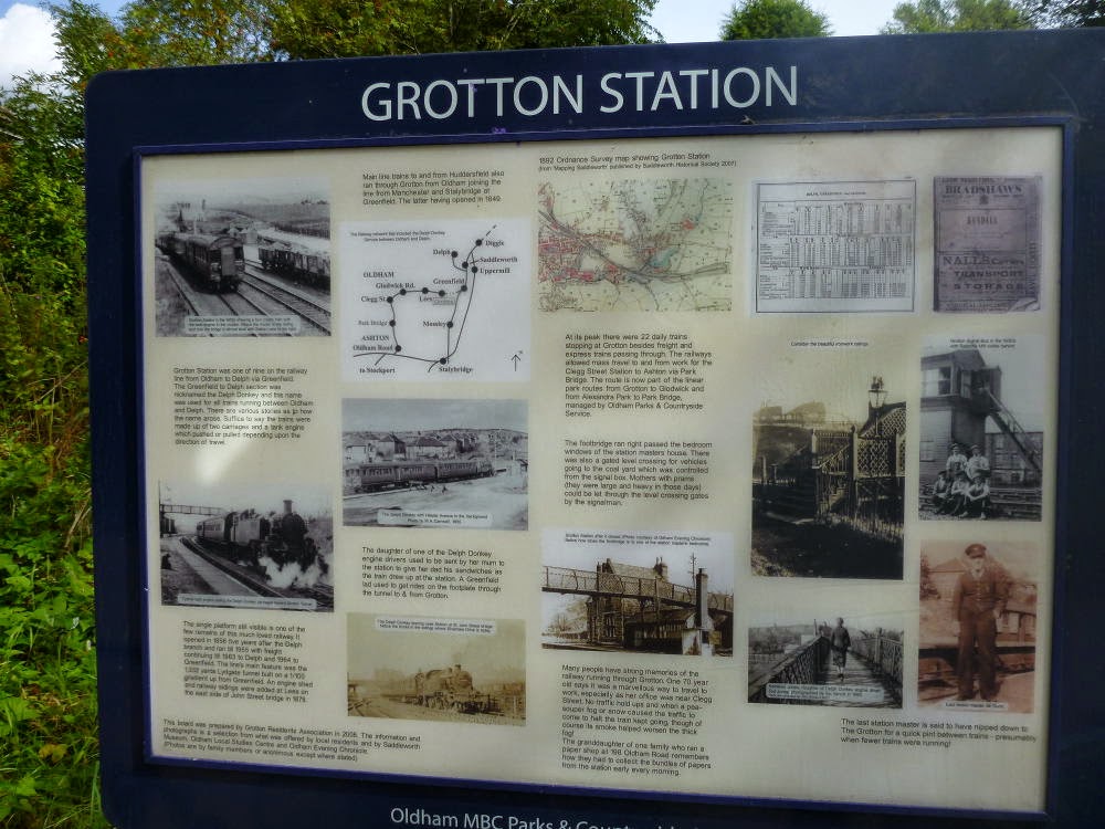
The station has this information board.
The platforms at Grotton Station are still clearly visible.

At this point Ian decided to check if he had missed the train :-)

Beyond this point the track becomes very wet and the cutting soon goes into Lydgate tunnel.

The big problem with this route is the way the cuttings have been infilled and the crossings are mostly level with the road. It is a shame, as it would have otherwise been an atractive route.
No comments:
Post a Comment