Sunday, 19 April 2015

Tyldesley Loopline 1 - Monton to Roe Green - Updated

This route is entirely traffic free and runs for just over one and a half miles along the disused trackbed of the Tyldesley Loopline in Salford. The Tyldesley Loopline was part of the London and North Western Railway's line from Eccles to Kenyon Junction on the Liverpool and Manchester Railway. The line opened in 1864 and closed in 1969. Part of this route is covered by a Herritage Trail leaflet.

This post covers the section from the site of Monton Green Station through Worsley Station to the junction with Roe Green Loop Line at Roe Green and has been updated with some new photos now that much of this section has been extensively resurfaced.

The site of Monton Green Station was several feet above this small roundabout on the B5229. The  station has been completely demolished, as has all sign of the line to the south. There is no signage at all on this road pointing out the start of the railpath, which is on the right just after the roundabout despite it being part of NCN Route 55.


This is the entrance, the winding path that begins behind the red barrier. There is no drop kerb or any other concession to pedal cycles. The entrance to the left of the picture leads to a brand new car park, so drivers have been well looked after...


The path leads up a short slope into the trees and straight into the one and only barrier on this section of path. It is a horrible U-bend barrier with a bike A-frame bypass. Enough to defeat some pedal cycles, but not as bad as many in Salford.


Once through the barrier you can get a glimpse of the car park on your left, and wonder how much it must have cost compared to the resurfacing of the path...


This first section of the path is well surfaces with a reddish tarmac. It runs along a wide embankment with trees on both sides. Unfortunately there has been little management of the trees and you get just a few glimpses of the open views on both sides.


To the left at this point is Broadoak Park the subject of a residents' battle to prevent it being built on, now a residents' victory and to the right is Worsley Golf Course.


About 3/4 of a mile up the path it crosses a stream on a rebuilt bridge


and brings you to the site of Worsley Station. Unlike most other former stations in the area, this one still has some reminder of it's existence with platforms on both sides.


At the end of the old platforms there is access via Hollyhurst, the old station access road up onto the A572 Worsley Road.


Here is where the resurfacing work starts. The new surface is a very smooth black tarmac without the usual grit finish, suitable for all cycles.


Just to the north the path passes under Worsley Road, through a rebuilt bridge, much smaller than the original.


The bridge is a corrugated iron tube and the old wooden gate that used to sit across the path here has been removed.


Beyond, the extensive drainage works can be seen on the left. Somewhere along here a short branch  line to the Bridgewater Canal joined this line from the left, but I have never noticed the junction amongst the various footpaths.


New access steps have been installed along the route with groves for wheeling a bicycle up and down, but they are useless for anything heavy or with a trailer.


At the bridge under the M60 the trees have been cut back and a new bench has been added.


However, there is still no lighting under the bridge.


A short way further on the trees on the left disappear, along with the embankment.


This is the site of a new United Utilities facility built to prevent sewerage getting into Kempnough Brook. It consists of an underground bifurcation chamber fitted with a powered screen, a 1,545m3 detention tank, a weir and a powered screen chamber.

This was the work that closed this route over the summer of 2013.


From here the trees close in again on the left along with an original wall holding back the cutting.


This section now leads to the junction at Roe Green, where the two bridges carry Greenleach Lane over the junction.


The bridge to the left straddles the continuation of the Tyldesley Loopline as it turns west. Here the tarmac ends.


Under the bridge to the right the resurfacing continues along the newer Roe Green Loopline which heads north for Bolton.


Continued in separate posts.

Tyldesley Loop Line 2

Roe Green Loopline 1


View Tyldesley Loopline 1 - Monton to Roe Green in a larger map


Portland Street Roadworks

Portland Street Bus Priority works have started in central Manchester. This is the scheme where, unlike Oxford Road, the City Council and TfGM have failed to design in proper segregated cycle provision. Now the roadworks have started, the road has been narrowed considerably and the bus lane is no longer in force, making it a really nasty place to cycle.


The central islands are currently being ripped out, and the road is currently one lane each way on the outer lanes of the road.


Despite the bus stops being suspended I still saw passengers being dropped off here.


And the pavement is no better.


Generally the place is worth avoiding, if you can.


It is becoming almost impossible to get round the city centre on a bike at the moment.

Sunday, 12 April 2015

Oldham to Grotton Railpath - via Leesbrook Nature Park

This route continues on from the Ashton to Oldham Greenway as it meets Park Road in Oldham.

This is the route taken by the "Delph Donkey".

http://www.ribblevalleyrail.co.uk/Delph/Delph%20Donkey%20Final%201.htm#Start
Map from Ribble Valley Rail web site

The start is decidedly unpromising, in the Matlan car park.


You have to ride round to the eastern corner of the car park


where you can find this, well hidden, entrance to the path.


The path runs alongside Woodstock Street, hidden behind the trees on the right


It then turns left before turning right over Waterloo Street on this bridge.


The path then opens out, running round the back of a factory car park and under a pedestrian bridge.


Further on it turns right and crosses Hamilton Street


before turning left and running alongside Southlink on a shared use pavement.


As the path moves away from the road it meets Glodwick Road. This is the former site of the Glodwick Road Railway Station, though no sign of it remains now. At this point the railway used to pass under the road, so the area has been extensively re-landscaped.


The path then crosses Moorhey Street. Again the railway would have passed under the road at this point, the stone wall appears to be the remains of the bridge parapet.


The next section includes a wiggly path in a slight cutting.


Next the path crosses Cranbrook Street, again on a level because of the infill.


Here the old railway cutting has some large rock for decoration.


However, it is clear that this section has been infilled with rubbish as the path has these ventilators are placed frequently along the path.


The next road to cross is Lees Road at the junction with Brewerton Road and Clarksfield Road.


The easiest way to do it is go to the right and go out onto Brewerton Road, cross Lees Road and then regain the path on Clarksfield Road above the left hand green box.


Again the cutting has been heavily infilled.


After crossing Clarksfield Street the path goes from tarmac to a gravel surface


and then to a rough surface with some mud, probably the original railway ballast, as here the line went from being in a cutting to an embankment.


The line would have crossed the wonderfully named Wellyhole Street on a bridge, at Bank Top, but the bridge has long gone, so it is yet another road crossing.


Here the path enters Leesbrook Nature Park


via some vividly coloured barriers!


Now the cycle path runs along the trackbed on the top of the embankment.


As the line runs into a cutting again, the infill has not been complete and the path manages to pass under the St John's Street bridge. Just beyond was the site of Lees Railway station.


This exit on the left gets you out onto Station Street.


After crossing Oldham Road the path then crosses Ashbrook Road - both on the level after infill.


The path then wiggles left,


then right


before approaching Grotton beside this little playground.


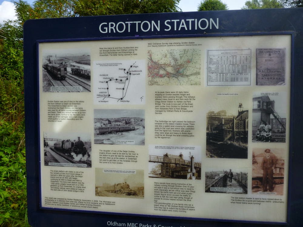
The station has this information board.


The platforms at Grotton Station are still clearly visible.


At this point Ian decided to check if he had missed the train :-)


Beyond this point the track becomes very wet and the cutting soon goes into Lydgate tunnel.


The big problem with this route is the way the cuttings have been infilled and the crossings are mostly level with the road. It is a shame, as it would have otherwise been an atractive route.


Wednesday, 8 April 2015

"Cycle Tracks" aka parking spaces for lazy contractors...

I am so sick of obstructions on cycle tracks in Manchester.

This evening's ride home met with this pair of vans.


There was no sign of either driver.


One van is on the legitimate access road, the other idiot drove down the cycle track!


Remember this name...


Sunday, 5 April 2015

Dantzic Street Closure

This recently created cycle cut-through has been closed off.


It looks like there are going to be several buildings demolished round here.


It is clear that the contractors don't care much for the cycle route!


This is what it used to look like...


Smashed Sign & Missing Bollards

Two weeks ago I posted pictures of the ludicrous "repair" of the bollards on Middlewood Street, and asked "How long before a passing HGV sends the sign and bollard flying?"

Well, the answer is less than two weeks...

This was the site two weeks ago,


and this is the site today.


I found the smashed road sign around 50 metres further down the road and the bollard was nowhere to be seen.


How long before TfGM and the local councils come to realise that this sort of plastic rubbish is a waste of money?