Sunday 24 January 2016

Curry Mile Cycle Tracks - early preview

I haven't been down Wilmslow Road for a few months, so I wasn't aware of the level of progress that is being made on the Curry Mile. The plans for this route were a real mixed bag. It was good that the council were aiming for proper cycle tracks, but the design completely failed to address the issue of safety at junctions.

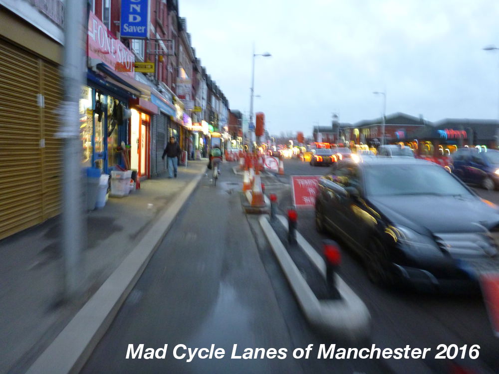
The section southbound from Rusholme Place is sort of open, so here's a quick preview of what it looks like so far...

The first thing you notice is the way the cycle track abruptly moves from the cycle lane across the junction, left to go behind the parking spaces.


The second problem is the attitude of the contractors who see no problem with dumping traffic signs in the cycle track, on the wrong side of the parked cars where no diver can see them.


At the junction with Banff Road you clearly see a problem with the way the kerbing is cut back to allow vehicles to swing round the corner into the path of cyclists. I suspect this will be a significant problem along much of this route. Drivers are invited into the junction by its shape rather than feeling that they are intruding, as would be the case if they were presented with a raised kerb to cross.


Past Banff Road you can see how somebody has responded positively to our concerns about people parking on the cycle track by putting in this continual row of half-height bollards (sadly only plastic). The nice thing is that they add a feeling of continuity and they help visually distinguish the cycle track from the pavement.


However, some of the larger gaps in the kerbing will provide the opportunity for drivers to get onto the cycle track and pavement. Stand by for lots of photos of taxis, vans & cars blocking places like this.


Further along there is another sudden lurch to the left and a narrowing of the track.


The track is already attracting people to cycle along it, and I saw very few people walking along it.


At the junction with Great Western Street the pavement has been sacrificed to allow two lanes of traffic at the junction and this phone box allows clear comparison with the original pavement, as well as causing another nasty kink in the cycle track. The cycle track is also very narrow in places, which makes me wonder how trikes will manage along here...


...particularly Errand Trike.

https://twitter.com/ErrandTrike

At the junction itself they have yet to sort out the traffic light too.


In general, the design has sacrificed pavement width to provide space for additional traffic lanes and unnecessary car parking.


At the junction with Dagenham Road there is another nasty kink in the track


followed by an unprotected junction and another nasty kink back to the left afterwards.


The open section of track currently ends at Denson Street. Here you can see another potential problem with the design. The drains are all in the cycle track, so it is, for the most part lower than the rest of the road surface. This means it is likely to end up blighted by puddles and the surface will degrade quickly in the winter.


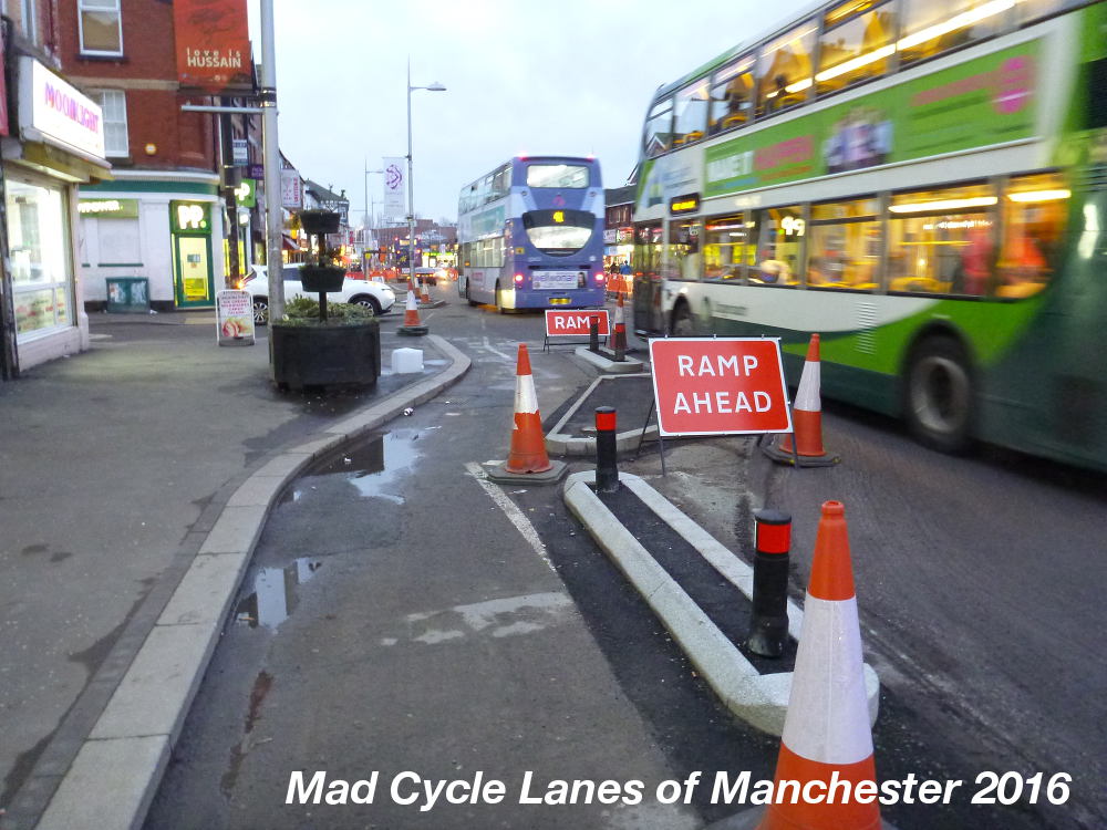
Here there is another unprotected junction. You currently have to get out onto the road and compete with the buses for space.


However, it may not be long till the next section is open. Here there are also full height bollards designating the edge of the pavement, not quite sure why.


All in all, the route looks like it will be a big improvement over the useless cycle lanes which slalomed round the bus stops, and left you fighting with buses cars and taxis for space. The main safety problem along here was caused by the bus stops and parking movements.

However, the poor design of the junctions poses a safety issue, and many are likely to come a cropper with the sudden changes in direction. I expect this route will see an increase in the level of cycling, but little change in the number of incidents. Time will tell.

Ultimately, there may be an even bigger danger resulting from this scheme. Bus drivers seem to be getting more aggressive towards people cycling along Wilmslow Road. Some now seem to think that anyone not in a cycle track is fair game, and I was cut up by a bus near Platt Fields Park and then shouted at for not using the tiny section of cycle track at that point. I suspect we may see much more of this kind of behavior in the near future as there is a history of similar behavior in Manchester.

Sunday 17 January 2016

Deliveroo - are they listenning?

Deliveroo - the company that employs motorists who don't care about invading cycle facilities,


particularly ASLs and cycle lanes.


Also seen bypassing other traffic rules...


Well, there has recently been a return to employing cyclists.


Also, they have adopted these backpacks which means the last few yards can be completed on foot.


Does this mean the company has been listening to recent criticism of the behavior of their motorcyclists?


Corporation Street CYCLISTS DISMOUNT

It just gets worse in Corporation Street.


Two DISMOUNT signs have turned up in Corporation Street on both sides of the road outside W.H. Smiths.


On both sides pathetic little tarmac ramps have been added, presumably this is to help you push your bike onto the pavement.


On the southbound side the ramp is quite dangerous as it forces anyone who continues cycling alongside the pavement into the tram tracks.


This chap clearly had other ideas about how to proceed...


There are other new signs in the area. To the north of Exchange Square station signs have appeared clearly indicating that cycling is allowed along here.


This probably explains the panic measures on the south side of the station.


The planning of the Second City Crossing has been an absolute disaster for cycling. Metrolink claim they consulted cycling organisations, but there is no sign at all that they have listened.

For more information...

Corporation St, Part 1 - heading north...

Corporation Street Part 2 - heading south...

Sunday 10 January 2016

Response to the “Strategic Plan for Manchester City Centre: 2015-18

Response to the “Strategic Plan for Manchester City Centre: 2015-18"

This document is at best a plan. It should not be described as a “strategy” since it lacks any overview of how Manchester City Centre functions and most importantly it lacks an overarching vision for the future of Manchester City Centre. It is also largely a backwards facing document, giving a lot of detail about past developments without properly addressing the plans for the future.

The documents also fail to join up with the forthcoming Manchester City Centre Transport Strategy and the wider transport and statutory plans for the area. The way in which the document lists tiny fragments of the area in separate sections, for example Castlefield is separated from Water Street and St John’s Square which fails to address the horrendous impact that the proposed “Sky” development will have on all these areas. Indeed, the separation of the document into sections covering small areas seems to have lead to some confusion and has resulted in some developments being listed in the wrong area.

The key element that is missing from this document are the people of Manchester. Their experiences of living, working, learning and carrying out daily life in the centre are completely absent. The document is all about “development”, “growth”, “investment”, “marketing” and other financial issues. It says very little about how people experience the city centre. It is as if the people of Manchester don’t matter…

Air Quality and Public Health

Air pollution is a major cause of ill health and early mortality in Manchester City Centre. It is a serious problem for all residents along with those who travel into the city for work or leisure. Tacking air quality should be the number one priority for the City Centre as it a major health issue and will put severe limitations on the growth of the area.

The other health crisis facing the people of the area is physical inactivity. The most important measure for the health of the people of this area will be to ensure that they can travel on foot and/or cycle for most, if not all of their daily journeys. The city centre must proritise walking and cycling as a matter of urgency as this will pay huge dividend for public health, both in reducing obesity and improving air quality

The Public Realm

Nowhere is this clearer than in the references to the public realm.

Take for example the references to St Peter’s Square. This area has suffered from the removal of the green space provided by the Peace Garden and the closure of Library Walk. The Cenotaph has been moved from its central position on the site of St Peter’s church and placed out of the way by the back door of the Council House in order to make space for a major tram station which will dominate the whole area.

Other public spaces suffer similar problems:

Piccadilly Gardens is a poor quality bus station and tram interchange with a small area of green space in the area remaining.
Exchange Square is also now given over to an oversized tram stop.
Albert Square is dominated by traffic on 3 sides and is predominantly used as an event space.
Deansgate is one of the most important public spaces in the city, hosting major events, and yet it is given over to traffic 99% of the time.

The only reasonable quality green space in the city centre are smaller areas like Sackville Gardens, St John’s Gardens and Parsonage Gardens. It is notable that there has been a significant loss of green space in recent years with the loss of the Peace Garden in St John’s Square and the loss of Hardman Square.

The city centre now lacks a major public space that gives the city an iconic location for events. There is a need to identify and carve out public space and prevent the further degradation of the few remaining spaces.

Deansgate should be closed to traffic and become a key piece of public realm all year round. It is a major desire line when travelling by bicycle and on foot.

Whilst the city centre has a desperate need for green spaces it has many large squares which are given over to car parking. In China Town the car park by Nicholas Street is a key location that should become green space, along with the Major Street and Aytoun Street car parks whilst the Bloom Street car park in the Village is a major blot on the landscape that should be converted into a high quality public space.

The contrast with developments in the City of Leicester are striking. Here whole areas of the city centre have been turned into public realm, given over to the movement of people on foot and cycling.

See http://www.uklandscapeaward.org/Entryfiles/1282044643statement.pdf

and https://www.leicester.gov.uk/media/179023/core-strategy-adopted-july-2014.pdf

Car Parking

The document admits that the city centre has in excess of 30,000 off road and 2,000 on-street parking spaces. This is a massive over supply of car parking in the city centre and with the impact of free parking on single yellow lines in the evening.

There needs to be a phased plan to halve the number of available parking spaces and increase charging to ensure that there is always space available for essential users.

Tackling Severance

A major problem for the city centre is severance caused by major roads. Most particularly the Mancunian Way is a major barrier for movement along with much of the inner ring road. The Mancunian Way should be declassified as soon as possible, removing its motorway status and putting a 30mph speed limit in place. The demolition of the Mancunian way would be a major step forward in regenerating the Corridor and surrounding areas.

Cycling

The provision for cycling in the City Centre is dreadful. Most direct routes involve getting off and walking. There needs to be a complete change of approach integrating cycling into the public realm and making all streets two way for cycling including those where traffic is excluded.

See how Leicester is achieving this:

http://www.theguardian.com/cities/2015/nov/26/lessons-from-leicester-the-uks-unlikely-new-poster-city-for-cycling

http://www.beta.leicester.gov.uk/media/67134/connecting-leicester-cycle-city.pdf

Saturday 9 January 2016

Irwell Towpath Closed in Ordsall

The floods over the holidays has done considerable damage to the Irwell Towpath in Ordsall. Opposite Pomona tram stop, next to Soapworks the path has been undermined, and much of this section was washed away. Further along the path also seems to be falling towards the river. The gate underneath the tram bridge has been locked shut, so this section is completely unusable and is unlikely to be repaired for many months, and possibly years.


This is in addition to the considerable amount of sand and silt that has been washed onto the lower parts of the path upstream.


So this leaves the many commuters who use this path looking for traffic free alternatives between Salford Quays and Manchester City Centre. You can cycle along Orsall Road, but I wouldn't recommend it.

There are two alternative traffic free routes, though both are unlit, so you need a good set of lights to negociate them at night. The route across Pomona is somewhat disconcerting in the dark, especially with the off-road motorbikes being ridden around, whilst the Bridgewater Canal Towpath is busier, making it feel safer, but you have to concentrate on the path surface to avoid ending up in the canal.

The nearest alternative is across Pomona. Go over the Green Bridge from Woden Street and then go through the gap in the fence on your right before the viaduct and along the muddy path. After a sharp drop the path turns into a wide gravel track.


Here you will be greeted by birdsong and the noise of the trams. Though the birds were quiet on Friday morning because of the presence of a kestrel hovering above the verge.


The track turns to tarmac in places, but watch out for some very deep potholes.


From the bridge over the lock between the Bridgewater Canal and the Irwell the route is then downhill to Pomona Tram Stop.


You then have to get onto the pavement to get through the gate.


From here you get a view of the damage to the towpath and see how it was undermined in the floods.


Then follow the road up to the roundabout by Throstle Nest bridge.


The other alternative route is through Castlefield Basin and along the Bridgewater Canal Towpath. This route has reopened as the remains of the collapsed building have now been removed from the path and the building has finally been demolished.

This is supposed to be an official Velocity Cycle route, but it is pretty poor. The cobbles are quite large and no attempt has been made to fill in the gaps, and on a small wheeled bike you could easilly catch your wheel in one of the gaps and find yourself being thrown into the canal.


There are also several steep bridges over the wharves, which will mean many people will have to get off & push.


The final bridge has a particularly poor surface.


Further along there is a very narrow bridge under a road, though thankfully there is now a handrail which makes it less scary.


And the open sections are covered in thick loose chippings, making it difficult to keep control of the bike, especially when passing cycles coming the other way as you end up on the thicker layers of gravel.


This route again brings you out at Throstle Nest Bridge.

From here there is another section of damage on the Trafford side of the towpath, though it hasn't been closed off yet.


Neither route is ideal, but both offer the chance to avoid the unpleasant experience of cycling on the roads and suffering the threats and abuse from passing motorists...