Showing posts with label Urban Vision. Show all posts

Sunday, 17 April 2016

Tyldesley Loopline Update, Roe Green to Ellenbrook

I last rode the Tyldesley Loopline between Roe Green and Ellenbrook back in August 2014.

Salford council held a consultation about improving this route last December and it seems that there have been some works carried out - sadly that has resulted in the route being almost un-ridable for the time being.

Starting at the junction with the Roe Green Loopline, the path is in reasonable condition.


There are signs of the trees having been cut back, but initially the surface is rideable.


However, the path worsens at this point.


It is seriously muddy, no place for racing bikes...


After the bridge under the East Lancs Road the path goes up steeply to the left and open water appears on the trackbed.


From here the path on the top of the embankment is a bit muddy, but rideable, whilst the trackbed looks more like a lake.


Once the path returns to the trackbed things get much worse


Here the preparation works have churned up the trackbed.


At this point it is very difficult to make progress. The mud is several inches deep in places, and you get wheelspin on the flat.


These conditions last all the way to Ellenbrook and the start of the guided busway.


All in all this route is almost unrideable and well worth avoiding until Salford Council get round to finishing the upgrade works.

Sunday, 13 March 2016

Armadillos, Broken Bollards and Crass Carparking

Welcome to Salford's shit cycle infrastructure.

Starting at the junction with the A576, this is Great Clowes Street in Salford. This is the start of a new set of cycle infrastructure, and it leaves a lot to be desired...


The cycle lane has only just started when it runs straight into a bus stop.


Next there is a plastic island with two plastic bollards. Note how the island is entirely in the cycle lane, not even on the white line. This makes the cycle lane feel crowded and, quite frankly threatening.


Next there are the armadillos - these useless items are a method of dumping waste plastic from Spain on the UK's roads. Note how these are placed well into the cycle lane rather than on the white line as was the case with the original trial on Middlewood Street and Liverpool Street.


These plastic lumps make cycling along this route very uncomfortable.


You quite quickly feel trapped between the armadillos which, because of their shape, could easily throw you into the road and the rubbish which is strewn in the cycle lane.


At the junction with Upper Camp Street, all the plastic falls away and the junction is totally exposed to oncoming traffic.


Beyond the junction the dirty, un-swept cycle route feels neglected and horrible.


At the junctions there is no protection. All the cars I saw emerging from side lanes blocked the cycle lane. Notice how this cycle lane then crashes into a bus stop.


In any location where there is a bus stop or a junction there is no physical protection whatsoever.

In other words, when it gets difficult and dangerous, you are on your own.


This bus stop show just how sharply a bus must swerve across the cycle lane to get into the bus stop.

This is dangerous!


Further along, this traffic cone, left in the middle of the cycle lane, demonstrates just how much Salford council really care about people cycling.


This area is strewn with broken glass and broken pieces of traffic cones.


And then we find the cycle lane blocked by a car...


Almost parked right up against the next set of bollards this car IS PARKED LEGALLY!

There are no double yellow lines...


On Broughton Bridge you approach the carnage of broken plastic...


Here traffic cones mark the locations where vehicles have smashed up the bollards, here one has been destroyed,


next both have disappeared.


As you move onto Blackfriars road there are more


and more broken bollards.


Followed by proof that the armadillos can't keep motor vehicles out of cycle lanes


provided by a "HIGHWAYS MAINTENANCE" driver who was fitting something to a nearby lamppost.


There are then a few more items of plastic in the cycle lane before


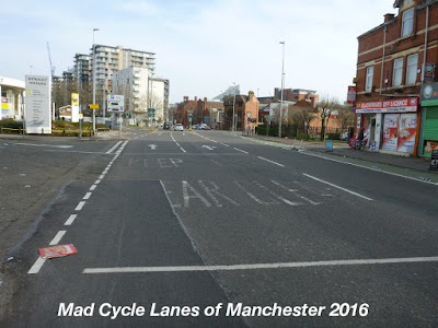
you are thrown into this expanse of tarmac as you approach Trinity Way.


After Trinity way there is a short burst of green paint


before the cycle lane turns into car parking spaces and charging points for electric cars.


Quite why this stretch is given over to parking is something only Salford Council can answer,


and at the end of it there was yet another car blocking the cycle lane.


At the junction with Viaduct Street there are lots of cones and road signs in the cycle lane.


Finally the cycle route ends in this bus stop.


The rest of the route into Manchester City Centre is just road.

Quite frankly this is horrible nasty, dirty and neglected.

Sunday, 30 November 2014

Tyldesley & Roe Green Loopline Closed

A colleague at work found his route to work along the Roe Green and Tyldesley Looplines blocked a couple of weeks ago, with no explanation.

The closure runs all the way from Worsley Station to Tynebank in Wallden.


He wasn't best pleased at having to carry his bike out onto the surrounding very busy road.


The closure notices finally appeared after two weeks.


It seems Urban Vision and Salford Council don't think that people cycling need to be given advanced warning along the route, giving them time to work out how they are going to navigate the surrounding roads. After all we don't all read their web site just in case our route to work is being closed.


Tuesday, 19 August 2014

Roe Green Loopline 1, Roe Green to Walkden

This route is entirely traffic free and runs for just over one and a quarter miles along the disused trackbed of the Roe Green Loopline in Salford. The Roe Green Loopline was opened in 1870 from Roe Green to Bolton, via Walkden Low Level. A key function of the lines was to support the surrounding collieries in conjunction with the Bridgewater canal, the largest of which was at Mosley Common, one of the biggest pits in the UK at its prime.

This post covers the section from the junction of the Tyldesley Loopline with the start of the Roe Green Loopline at Roe Green to Walkden. It is a continuation of a previous post Tyldesley Loopline 1 - Monton to Roe Green.

At Roe Green the two bridges carry Greenleach Lane over the continuation of the Tyldesley Loopline to the left as it turns west and the newer Roe Green Loop Line to the right which continues north heading for Bolton.


This post takes the right fork along the Roe Green Loopline.


The path runs straight in a northwesterly direction from here. The surface isn't too bad comparedto the muddy conditions near the M60 to the south east.


After a short while the path passes under the East Lancashire Road.


Then it opens out for around half a mile


with the trees encroaching occasionally.

This is around the north western end of the planned improvement works.

According to an email from Urban Vision:
Phase 6 and 7 improvements, of approximately 2.4km, will begin at Worsley Station (the original railway station) in Worsley, passing under the motorway bridge towards Roe Green and under the East Lancashire Road to Mesne Lea Primary School. This 600k project will link the existing improvements from Tynesbank through to Monton Green and will include re-surfacing works, the installation of drainage, the construction of access paths and steps, as well as the installation of benches along the route. Urban Vision has completed design of the scheme, and it is now proposed to go out to tender on 25th July 2014, with a view to the works starting at the end of October for a 14 week period. It is anticipated the works will be completed by early February 2015.

My main concern is that the path is likely to be closed for 3 months and that they do not install any new barriers or other obstructions on the route


The path then passes under the Walkden Road


through the site of the Walkden Low Level station which has left no trace on the ground and under Park Road


then under this high railway bridge


and then the Bridgewater Road.


Soon there is a junction with the route of a railpath running towards the south west. This is labled the Hilton Lane Loopline on a map I have from Salford Council, but this does not match up with anything I can find. Further research needed, but this line leades down towards Ellenbrook and will be the subject of another post.


The path then rises towards Parsonage Road, take the right fork here


which takes you to the cycle barrier.


From here the rail path continues towards Bolton. The next post goes to the edge of Salford on the M61 and the boundary with Bolton.


View Roe Green Loopline1 in a larger map